NVDB support (Norway National Road Database)
Mapspace supports the addition of data from NVDB, the Norway National Road Database, and the query and edition of this data. For this type of action the user must have the appropiate permissions.
NVDB data is publicly accesible through several API:
- For reading data:
- For writing data:
The current version of the Read API supported is the version 3. For road subsections both v.2 and v.3 are supported for the Read API.
NVDB data is basically comprised of two types of objects:
- Road subsections. Any norwegian road registered in NVDB has a unique ID that identifies it. The road is split into smaller parts called strekning (sections) and sections also subdivided in delstrekning (subsections). Road subsections can be requested as a layer in Mapspace. Roads can be requested both in version 2 and 3 of the NVDB API.
- Road objects. Any object, event or incident related to a road is registered in the NVDB. Each object belongs to an object type. There are over 400 different types of objects that can be requested. Each object type can be requested as different layers in Mapspace. Objects can be requested in version 3 of NVDB API only.
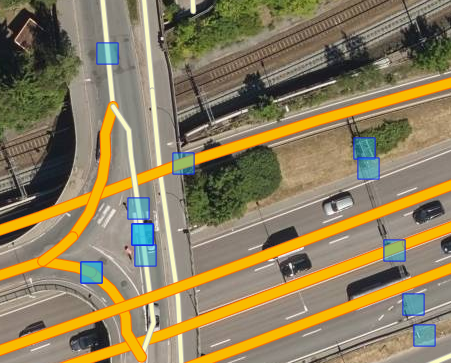
The following image shows both types of NVDB objects added: road subsections and road sign posts.
The functionality currently available in Mapspace for supporting NVDB data includes:
- Add NVDB objects as layers.
- Change layer style for road objects. Road subsections have a predefined categorized style that cannot be changed.
- Filter NVDB road objects using query conditions.
- Persist the configuration of NVDB layers in the workspace.
- Select NVDB objects and show them as selected both in the viewers and the Feature Panel.
- Create a new NVDB road object. Road subsections cannot be created.
- Modify the geometry of an existing NVDB road object. Road subsections cannot be modified. Modifications to the geometry can be done using snapping options defined per layer.
- Set an existing NVDB road object as deleted. This is not available for roads subsections.
- Modify the attributes of an existing NVDB road object following the rules imposed by the NVDB Catalogue.
- Add or remove attributes of an existing NVDB road object.
- Copy attribute values to clipboard.
- Reset the changes in attributes while features are selected.
- Add a NVDB referense to a road following the rules imposed by NDVB services as valid references.
- Reverse geocode a NVDB road reference for any point in the viewer both in V.2 and v.3 reference system. Show this references when doing a snapshot of a viewer.
- Show the related sub-objects of a given NVDB road object.
- Modify related sub-objects (add or remove), using existing NVDB road objects or newly created ones.
- Set any modification to an object (geometry, attributes or relationships) as an udpate (oppdater) or correction (korriger).
- Set a deletion of an object as a closing (lukk) or as a removal (fjern).
- Duplicate an existing or new road object.
- Persist all the changes made (creation, modification or deletion) in a temporary Mapspace service. Changes are saved on-the-fly as the user works.
- Export features to different formats: GeoJSON, WKT, KML, and ZIP with several of the previous formats in one file.
- Export changes to Datafangst format, a format supported by NVDB administrators for modifications exchange.
- Create collections of features called work lists that can be persisted in the workspace and opened/edited in any viewer.
- Validate and send changesets to NVDB Write Service that accepts changes to objects online. This option is only available for authorized users and require an extra login to NVDB services.
All the functionality is available in any viewer type (Map, Oblique, Street or 3D).
For a full explanation on the use of the NVDB functionality check here: