Introduction to Mapspace
What is Mapspace
Mapspace is a web-based application that allows to experiment with all the features and power of the Mapspace geoservers.
Mapspace are online services provided by Field Group from several computing centres worldwide, offering a revolutionary collection of geographical datasets showing urban environments with high-definition imagery and LiDAR 3D models, extracted from at least five different views and accurately geo-referenced to fulfill both end consumer expectations and professional/engineering requirements.
As such, Mapspace offers a wide set of APIs, GIS Plug-ins and SDKs for developers to create high added-value applications on a wide range of platforms and technologies on top on the rich and unique geographic content provided by Field Group, and other contents provided by Field Group partners.
Mapspace was developed to supply a convenient, ready-made and easy to use tool that provides access to the geographical content found in Mapspace, without the need for end user coding.
Mapspace makes full use of the Mapspace JavaScript API in order to provide a wide showcase of Mapspace capabilities in terms of functionality and available datasets. This way, Mapspace is located at the top of Field Group Product Value Chain.
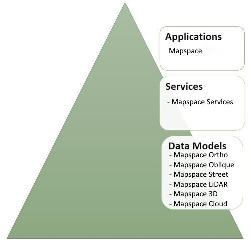
Mapspace has been designed to cover two basic needs:
-
Provide a simple yet powerful way to showcase Mapspace features to Field Group customers, and also be a demoing tool for the Field Group Sales Force.
-
Provide a solid basic core for developers to create vertical web applications using the Mapspace JavaScript API.
Future versions of Mapspace will include additional tools and functionalities and will allow for greater interface customization capabilities.
What is in this document?
This document is a reference guide for Mapspace. It provides a simple but detailed user manual covering all of its features.
Supported Platforms
Mapspace runs on any JavaScript compatible web browser, whatever the operating system. It has been tested and is supported in latest versions of Microsoft Edge, Mozilla Firefox, Opera and Google Chrome.
Accessing Mapspace
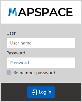
As stated in the previous section, Mapspace is hosted at the following URL:
To access the tool you will need to type in your credentials provided to you by a Field Group Sales Support representative.
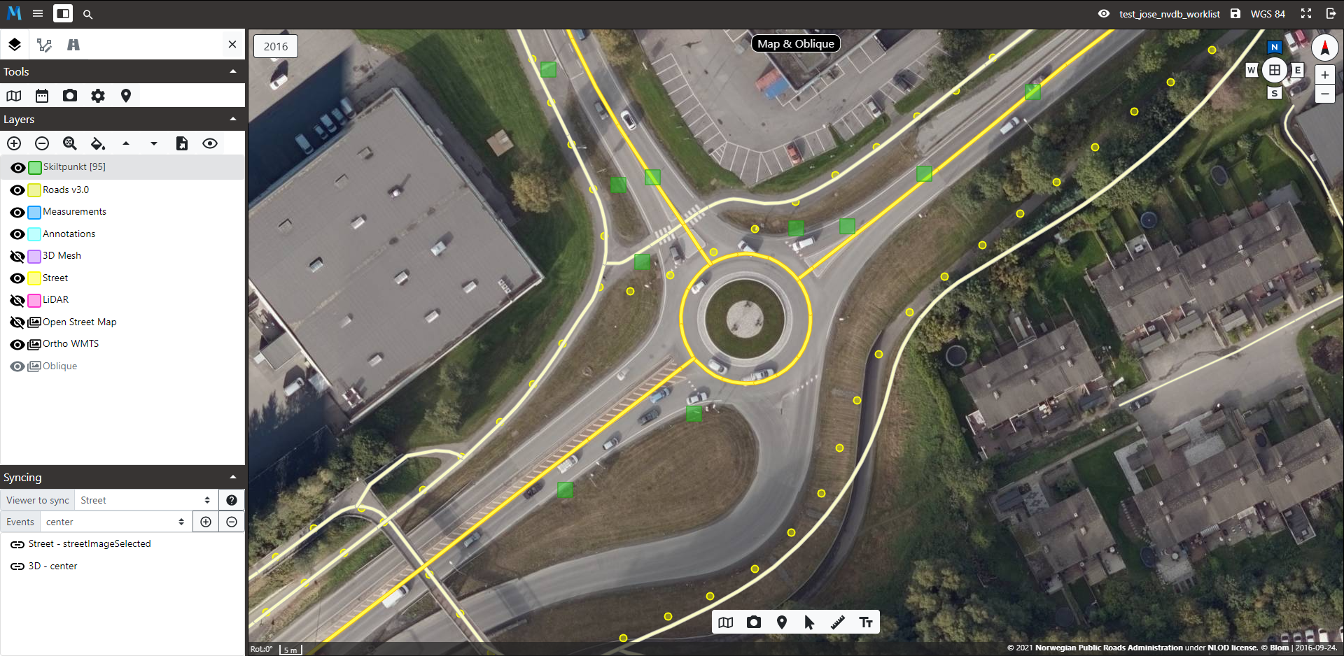
This will lead you to Mapspace main screen displayed below. We will refer to this picture in the following sections to locate controls and functions.
The Remember me checkbox will allow you to store your credentials on the computer you are using so you will not need to type them on any session. Use this option with caution on shared computers.
Automatic access (without typing user and password) based on source IP address is now supported. You must contact to your Field Group Sales Support representative in order to add your public IP address to our white list.
Mapspace Main Features
Mapspace is a web-based viewer built using the Mapspace JavaScript API and Mapspace 3D Mesh API, which provides full access to more than 4000 cities in Europe and vector map data for all of Europe.
Mapspace features can be summarized as:
Navigation capabilities: Mapspace allows users to search information and navigate through it in several ways.
- Geocoding tool
- Coordinates search
- Zoom and pan
- Map Locator
- Display of ortho and oblique imagery as well as vector map data.
- Mapspace Street: 360° Spherical Images available as demo scenarios
- Mapspace LiDAR: LiDAR data available online
- Profiles 3D viewer for LiDAR data
Extended visualization capabilities: Mapspace provides features that enhance the user experience when working with the existing geodata.
- Dual View and Multi View
- Easy connection to external WMS/WMTS Servers
- Street map overlay on Ortho and Oblique imagery
- Quick selection of historical imagery
- Multiple Oblique views for every point, easy to select
- User Layer selection capability
- Reverse Geocoding
- Identification of coordinates on screen
- Measurement capabilities on maps, oblique, street images & LiDAR models
- Annotation functions: ability to draw point, lines, polygons and text on screen
- Display of Point of Interest (POI) layer (where available)
- Skin capabilities to customize the look and feel of the application, including the option to upload a custom logo.
- High resolution imagery download available for customer keys
Measurement toolkit: Mapspace provides a powerful set of measurement tools that allow users to perform calculations directly on the images without the need for coding or use of external GIS Tools.
- Length tool
- Length on the ground tool
- Area tool
- Height tool
- Bearing tool
- Diagonal (ladder) measurement tool
- Elevation tool
- Vertical Area Tool
- Workspace and Custom layers: Mapspace lets users upload and store information on the server for later use.
- Upload of vector files for displaying on top of the imagery
- Save and retrieve workspace information
- Export annotation layer to standard formats
- 3D Capabilities: Mapspace 3D Mesh is now integrated in the viewer making it possible to:
- Display a specific model based on the available geo-coding tools.
- Pan, rotate, zoom and tilt the camera to visualize the models
- Change between the different available LODs for the models.
- Select the desired level of quality for displaying
- Enter editing model to add/delete buildings and change/add new textures
Future versions of Mapspace will include additional features. Refer to the Mapspace Product Roadmap for additional information. The following sections detail all of these features.
Mapspace User Roles
The application will support two user types, Super-user & Basic user. The role assignement will be handled by the Mapspace Team. So, any action related with the roles must be requested to the your Field Group contact.
- Super-user. This user will have full capabilities of management of Workspaces, Synchronization and Debug mode.
- Basic-user. This user will have limited capabilities on Workspaces, debug mode and no options on viewer synchronization edition.
The user roles management will be handled by the Mapspace team. You must contact to your Field Group Sales Support representative in order to request any modificion on the user profiles.