Vertical and Oblique Orthorectified Image Services
Overview
Oblique images are obtained with an inclination of approx. 45º allowing the users to see the facades of the buildings. These images are not ortho images and need to be treated specially.
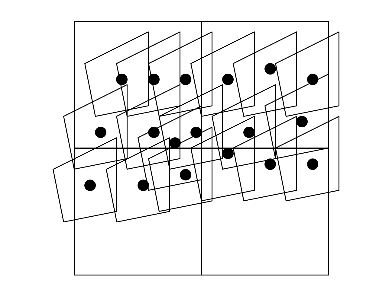
When an area has oblique images available, it normally has 4 available views for every point: North, East, South and West. And more than one image of any view could cover one particular point, since the images have some overlap between then.
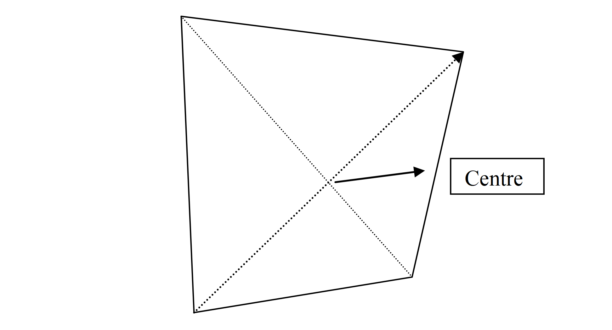
Every oblique picture has a centre. The coordinates of this point serve as an identifier to every image, and will also be used to select, among the different images covering a particular point, which one will be the best option for that point. The best image will be the one with its centre closer to the point as shown below.
Example of coverage of a set of images:
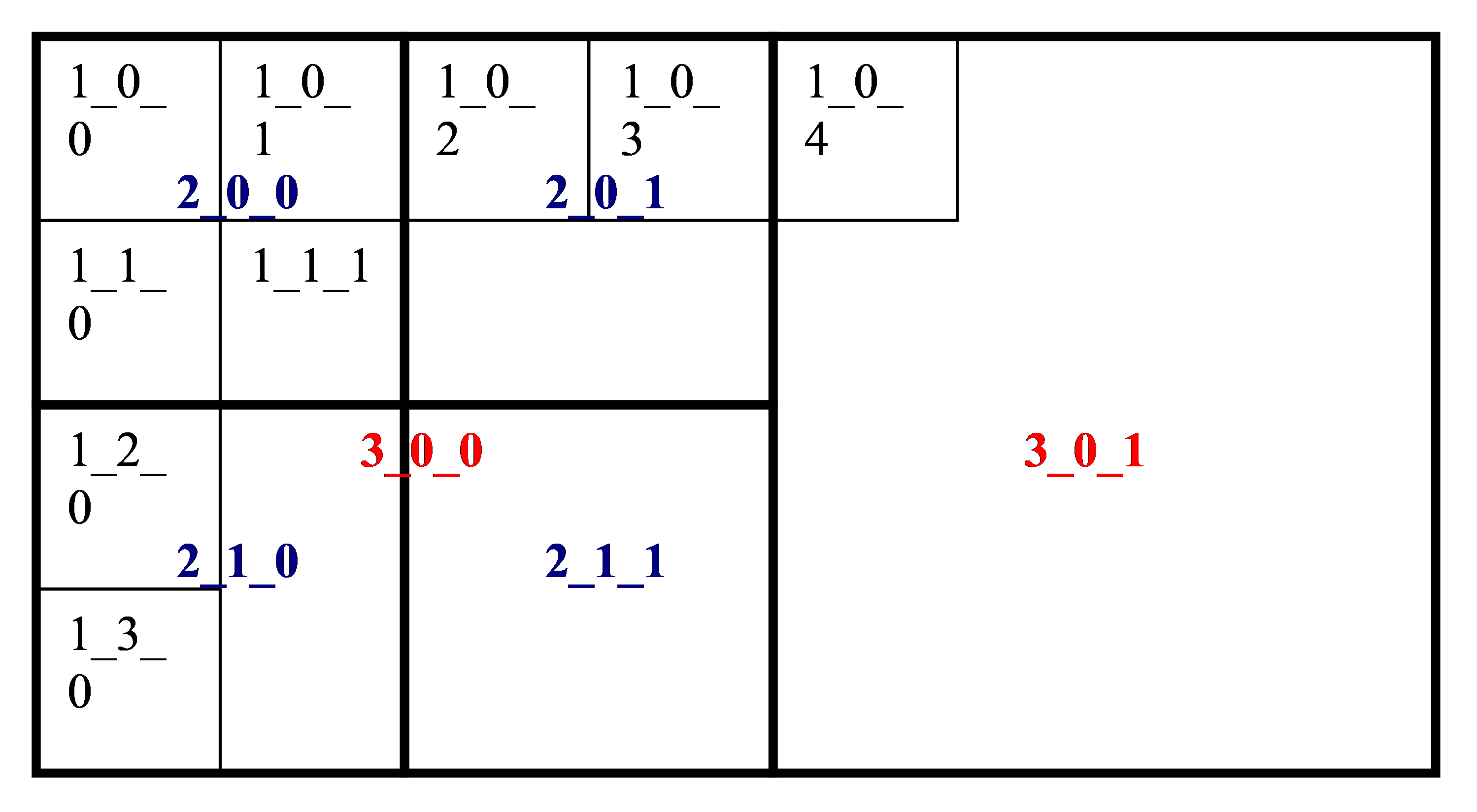
For a better performance each particular oblique image is cut into tiles 256x256 pixels in size. These tiles are available at several resolutions: Maximum Image resolution, ½ resolution, ¼ resolution and 1/8 resolution. These different scales are called zoom levels and are referenced as: 1, 2, 3 and 4 in the oblique images handling services.
Next picture shows an example of how the oblique images are cut into tiles. The code used to identify the tiles has 3 parts: the zoom level, and a pair of x, y coordinates of the tiles referenced to the upper left corner of the image.
Locating a tile
To find the tile where a particular pixel (of the original oblique image) is located at a given zoom level, this formula can be used:
tileX = floor(pixelX / (256 * 2 level-1))
tileY = floor(pixelY / (256 * 2 level-1))
And the position of the original pixel within the tile:
Xoffset = (pixelX – tileX * 256 * 2 level-1) / (256 * 2 level-1)
Yoffset = (pixelY – tileY * 256 * 2 level-1) / (256 * 2 level-1)
All pixel coordinates are referred to the top-left corner of the images.
Oblique Image Identifier
The identifier of any oblique image, follows this structure:
**OXXXX.XXXXXX_YY.YYYYYY_YYMMDD**
Where:
The first character (O) indicates the orientation of the image, being:
- N- North
- S-South
- E- East
- W-West
Characters from position 2 to 12 (XXXX.XXXXXX) represent the longitude of the photo center in LAT/LON WGS84.
The characters from position 14 to 22 (YY.YYYYYY) represent the latitude of the centre of the photo in LAT/LON WGS84.
The final 6 characters (YYMMDD) represent the date in which the photography was taken, (YY=year, MM=month, DD=day).
Example:
The image with this Id:
N-004.697670_40.655723_060830
has its center located at Longitude -4.697670, Latitude 40.655723 and was taken on August, 30; 2006.
DAObliqueTile
This service returns a tile of a oblique image specified in the request by the image ID and the tile ID.
The desired tile to cover a given point at a desired Zoom Level can be calculated from the data provided in the FindOblique or FindObliques services as follows:
X = PositionX / ( 256 * 2 (Zoom_level – 1))
Y = PositionY / ( 256 * 2 (Zoom_level – 1))
In addition to aerial images, Mapspace can deliver overlay data. This is rasterized vector data with transparency, which can be displayed on top of the images. This information is delivered as transparent png files and grouped in layers.
Layers can have information for one or all of the supported views, so that the information properly matches the different image views.
DAObliqueTile Parameters
The parameters needed in the request URL are the following:
- id [mandatory]: This is the identifier of the oblique image the tile belongs to.
- meshid [mandatory]: Tile mesh coding inside the Mapspace structure, as follows.
- T_Y_X, where:
- T zoom level: 1,2,3 or 4
- Y Row occupied by the tile in the provided zoom level
- X Column occupied by the tile in the provided zoom level
- T_Y_X, where:
- userkey [mandatory]: User’s key for authentication purposes. This key is unique for each client and must be requested to Field Group.
- olayer [optional]: If this parameter is present, the service will return tiles from the specified overlay layer instead of aerial images. Mapspace provides a “generic” overlay layer, with streets, roads and main administrative divisions.
Usage
https://your.mapspace.com/mapSvcs/DAObliqueTile?userkey=XXXXXX&id=N-004.697670_40.655723_060830&meshid=2_2_2
The result of the request will be a JPG image. If the user is not authorized to get the requested data or if the requested tile is not available, a transparent PNG file 256 x 256 pixels will be returned.
Overlays are returned as PNG images.
SEOblique
This service will locate the best oblique image that covers a given point.
SEOblique Parameters
The parameters needed in the request URL are the following:
- x [mandatory]: Coordinate x or longitude in the specified projection system.
- y [mandatory]: Coordinate y or latitude in the specified projection system.
- crs [mandatory]: Projection system used, It must follow OGC nomenclature. For example EPSG:32630 for WGS84 UTM 30 North or EPSG:3857 for Spherical Mercator projection.
- view [Optional]: Parameter that specifies which is the desired orientation view of the searched image. The possible values for this parameter are:
- N North Orientation.
- S South Orientation.
- E East Orientation.
- W West Orientation.
- * Signals that all orientations must be considered. It will return the best oblique for every orientation. If this parameter is not present, yaw must be used.
- yaw [Optional]: Parameter that specifies orientation angle of the oblique image in degrees between 0 and 360. It returns the oblique image with the nearest angle. If this parameter is not present, view must be used.
- output [mandatory]: Response format. Possible values are:
- txt: Response is a text string with comma-separated values (“,”).
- Xml: Response is an XML file.
- Json: Response in Json format.
- date [optional] : A date following the structure YYYYMMDD or YYYYMM or YYYY. The service will use the most current images available, whose date is previous to the requested date. It is also possible to use a range of dates with the structure YYYYMMDD-YYYYMMDD, in this case the images used will be the most current ones available in the specified date range. If the parameter is omitted the system will submit the most recent version of the tile.
- userkey [mandatory]: User’s key for authentication purposes. This key is unique for each client and must be requested to Field Group.
- layer [optional]: Identifies which oblique layer the user is requesting. Possible values are obtained with the INGetUserAvailableObliqueLayers service.
Error messages
If no images are found for the specified point an Error message is returned. If the response format was specified as a text, the response message is:
ERROR, Error message text
If the response format is XML the error XML file is:
<?xml version="1.0" encoding="ISO-8859-1" standalone="no" ?>
<result>
	<Error>
		ERROR, Error message text
	</Error>
</result>
Usage
The https request for searching the best oblique image for only one orientation would be like this:
https://your.mapspace.com/mapSvcs/SEblique?userkey=XXXXXX*&x=-523000&y=4961500&crs=EPSG:3785&yaw=0&format=txt
The response for this request is a comma-separated text string like the one shown below:
N-004.697670_40.655723_060830,1755.5,1973.5,4008,2672,-523426.5274033113,4962294.095442287,-522473.90464922023,4962036.324639748,-523329.81442120374,4961408.951368517,-522625.86237766274,4961300.148025963
The following table details the meaning of each field in the example. Data is provided as described in section 3.3.4
N-004.697670_40.655723_060830	Oblique image Id
1775.5	Pixel coordinate X in the image
1973.5	Pixel coordinate Y in the image
4008	Number of columns of the oblique image
2672	Number of rows of the oblique image
-523426.5274033113	Upper-Left corner, X coordinate
4962294.095442287	Upper-Left corner, Y coordinate
-522473.90464922023	Upper-Right corner, X coordinate
4962036.324639748	Upper-Right corner, Y coordinate
-523329.81442120374	Lower-Left corner, X coordinate
4961408.951368517	Lower-Left corner, Y coordinate
-522625.86237766274	Lower-Right corner, X coordinate
4961300.148025963	Lower-Right corner, Y coordinate
The coordinates of the four corners of the image are provided in the reference system specified in the request.
For each oblique image located the following information is provided:
- The oblique ID
- Position X, pixel coordinate in the image
- Position Y, pixel coordinate in the image
- The number of columns of the photography
- The number of rows.
- Upper-left corner x coordinate
- Upper-left corner y coordinate
- Upper-right corner x coordinate
- Upper-right corner y coordinate
- Lower-left corner x coordinate
- Lower-left corner y coordinate
- Lower-right corner x coordinate
- Lower-right corner y coordinate
If Layer parameter is present on the result will include the layer name.
In case of Json format, the output response will include the next parameters:
- Yaw: Oblique shot bearin angle in degrees
- copyright: Image copyright information
- tegid: TEG Model identifier for delegate client geo-referencing.
- epsg: EPSG code of image Externa Orientation projection
- has_teg: TEG Model availability
- oblparams: EO & CC params for delegate client geo-referencing [camera longitude, camera latitude, camera altitude, ground elevation, focal length, focal plane width, focal plane height, principal point x, principal point y, rotation matrix 9 params and internal affine transform 6 params]
SEObliques
This service returns information of all available oblique images covering a given coordinates.
SEObliques Parameters
Parameters of the service are described below:
- x [mandatory]: Coordinate x or longitude in the specified projection system.
- y [mandatory]: Coordinate y or latitude in the specified projection system.
- crs [mandatory]: Projection system used, It must follow OGC nomenclature. For example EPSG:32630 for WGS84 UTM 30 North or EPSG:3857 for Spherical Mercator projection.
- view [mandatory]: Parameter that specifies which is the desired orientation view of the searched image. The possible values for this parameter are:
- N North Orientation.
- S South Orientation.
- E East Orientation.
- W West Orientation.
- * Signals that all orientations must be considered. It will return the best oblique for every orientation. If this parameter is not present, yaw must be used.
- yaw [Optional]: Parameter that specifies orientation angle of the oblique image in degrees between 0 and 360. It returns the oblique image with the nearest angle. If this parameter is not present, orient must be used.
- output [mandatory]: Response format. Possible values are:
- txt: Response is a text string with comma-separated values (“,”).
- Xml: Response is an XML file.
- Json: Response in Json format.
- date [optional] : A date following the structure YYYYMMDD or YYYYMM or YYYY. The service will use the most current images available, whose date is previous to the requested date. It is also possible to use a range of dates with the structure YYYYMMDD-YYYYMMDD, in this case the images used will be the most current ones available in the specified date range. If the parameter is omitted the system will submit the most recent version of the tile.
- layer [optional]: Identifies which oblique layer the user is requesting. Possible values are obtained with the INGetUserAvailableObliqueLayers service.
- userkey [mandatory]: User’s Key for authentication purposes. This key is unique for each client and must be requested to Field Group.
Error messages
If no images are found for the specified point an Error message is returned. If the response format was specified as a text, the response message is:
ERROR, Error message text
If the response format is XML the error XML file is:
<?xml version="1.0" encoding="ISO-8859-1" standalone="no" ?>
<result>
	<Error>
		ERROR, Error message text
	</Error>
</result>
Usage
Following is an example of a request for searching all oblique images covering a given point, in a given orientation:
https://your.mapspace.com/mapSvcs/SEObliques?userkey=XXXXXX&x=-523000&y=4961500&crs=EPSG:3785&view=N&output=xml
The result of the request would be like this:
<?xml version="1.0" encoding="ISO-8859-1" standalone="no" ?>
<result>
	<metadata>
		<getIdOblique>N-004.697670_40.655723_060830</getIdOblique>
        <PositionX>1755.5</PositionX>
        <PositionY>1973.5</PositionY>
        <ImageCols>4008</ImageCols>
        <ImageRows>2672</ImageRows>
        <ulx>-523426.5274033113</ulx>
        <uly>4962294.095442287</uly>
        <urx>-522473.90464922023</urx>
        <ury>4962036.324639748</ury>
        <llx>-523329.81442120374</llx>
        <lly>4961408.951368517</lly>
        <lrx>-522625.86237766274</lrx>
        <lry>4961300.148025963</lry>
	</metadata>
    <metadata>
        <getIdOblique>N-004.698549_40.653011_060830</getIdOblique>
        <PositionX>2209.5</PositionX>
        <PositionY>589.5</PositionY>
        <ImageCols>4008</ImageCols>
        <ImageRows>2672</ImageRows>
        <ulx>-523574.4616112104</ulx>
        <uly>4961819.393668511</uly>
        <urx>-522578.85866889096</urx>
        <ury>4961701.5386721995</ury>
        <llx>-523413.3038055277</llx>
        <lly>4960965.542452324</lly>
        <lrx>-522667.1530365837</lrx>
        <lry>4960928.2444666</lry>
    </metadata>
    <metadata>
        <getIdOblique>N-004.696866_40.657295_060830</getIdOblique>
        <PositionX>1133.5</PositionX>
        <PositionY>2631.5</PositionY>
        <ImageCols>4008</ImageCols>
        <ImageRows>2672</ImageRows>
        <ulx>-523425.14571692346</ulx>
        <uly>4962492.926705989</uly>
        <urx>-522340.4629477161</urx>
        <ury>4962564.940425159</ury>
        <llx>-523207.1889110433</llx>
        <lly>4961479.661125997</lly>
        <lrx>-522465.6373291253</lrx>
        <lry>4961538.232155216</lry>
    </metadata>
</result>
For each oblique image located the following information is provided:
- The oblique ID
- Position X, pixel coordinate in the image
- Position Y, pixel coordinate in the image
- The number of columns of the photography
- The number of rows.
- Upper-left corner x coordinate
- Upper-left corner y coordinate
- Upper-right corner x coordinate
- Upper-right corner y coordinate
- Lower-left corner x coordinate
- Lower-left corner y coordinate
- Lower-right corner x coordinate
- Lower-right corner y coordinate
If Layer parameter is present, the result will include the layer name at the end of the list.
In case of Json format, the output response will include the next parameters:
- Yaw: Oblique shot bearin angle in degrees
- copyright: Image copyright information
- tegid: TEG Model identifier for delegate client geo-referencing.
- epsg: EPSG code of image Externa Orientation projection
- has_teg: TEG Model availability
- oblparams: EO & CC params for delegate client geo-referencing [camera longitude, camera latitude, camera altitude, ground elevation, focal length, focal plane width, focal plane height, principal point x, principal point y, rotation matrix 9 params and internal affine transform 6 params].
INObliqueDates
This service returns information of all available oblique dates (years) of a given coordinate.
INObliqueDates Parameters
Parameters of the service are described below:
- x [mandatory]: Coordinate x or longitude in the specified projection system.
- y [mandatory]: Coordinate y or latitude in the specified projection system.
- crs [mandatory]: Projection system used, It must follow OGC nomenclature. For example EPSG:32630 for WGS84 UTM 30 North or EPSG:3857 for Spherical Mercator projection.
- yaw [Optional]: Parameter that specifies orientation angle of the oblique image in degrees between 0 and 360. It returns the oblique image with the nearest angle. If this parameter is not present, orient must be used.
- output [mandatory]: Response format. Possible values are:
- txt: Response is a text string with comma-separated values (“,”).
- Xml: Response is an XML file.
- Json: Response in Json format.
- layer [optional]: Identifies which oblique layer the user is requesting. Possible values are obtained with the INGetUserAvailableObliqueLayers service.
- userkey [mandatory]: User’s Key for authentication purposes. This key is unique for each client and must be requested to Field Group.
Error messages
If no images are found for the specified point an Error message is returned. If the response format was specified as a text, the response message is:
ERROR, Error message text
If the response format is XML the error XML file is:
<?xml version="1.0" encoding="ISO-8859-1" standalone="no" ?>
<result>
	<Error>
		ERROR, Error message text
	</Error>
</result>
Usage
Following is an example of a request for obtaining all oblique dates ina given point, in a given yaw angle:
https://your.mapspace.com/mapSvcs/INObliqueDates?userkey=XXXXXX&x=10.712727572988204&y=59.92989925840692&crs=EPSG:4326&yaw=348&layer=Mapspace:NORTH&output=json
The result of the request would be like this:
{ "success": true,
	"years":[
    	2006,2008,2010,2012,2014,2016,2018
       	]
}
DAObliqueImage Service
This service returns a full oblique image. The image will be returned at a given zoom level.
DAObliqueImage Parameters
Parameters of the service are described below:
- id [mandatory]: Id of the oblique image from which to extract the image.
- zoom [mandatory]: Desired zoom level for the oblique image.
- Zoom=1 for level 1:1
- Zoom=2 for level 1:2
- Zoom=3 for level 1:4
- Zoom=4 for level 1:8
- userkey [mandatory]: User’s key for authentication purposes. This key is unique for each client and must be requested to Field Group.
Usage
Example of an DAObliqueImage request with Oblique Id provided:
https://your.mapspace.com/mapSvcs/DAObliqueImage?userkey=XXXXXX&id=N-003.702380_40.415195_090718&zoom=1
The result of this request would be complete oblique JPEG image in North orientation, zoom level 1.
If the user is not authorized to get the requested data or if the requested image is not available, an JPG file with the text “unauthorized” is returned.
DAObliqueImagePiece Service
This service returns a portion of an oblique image. The image will be centered at a given point and zoom level.
If an oblique image Id is not specified, the system will automatically select the best oblique for the point and extract the data from this image.
DAObliqueImagePiece Parameters
Parameters of the service are described below:
- x [mandatory]: Coordinate x or longitude in the specified projection system.
- y [mandatory]: Coordinate y or latitude in the specified projection system.
- crs [mandatory]: Projection system used, It must follow OGC nomenclature. For example EPSG:32630 for WGS84 UTM 30 North or EPSG:3857 for Spherical Mercator projection.
- id [Optional]: Id of the oblique image from which to extract the image.
- view [mandatory]: Parameter that specifies which is the desired orientation view of the searched image. The possible values for this parameter are:
- N North Orientation.
- S South Orientation.
- E East Orientation.
- W West Orientation.
- width [mandatory]: Returned image width in pixels.
- height [mandatory]: Returned image height in pixels.
- zoom [mandatory]: Desired zoom level for the oblique image.
- Zoom=1 for level 1:1
- Zoom=2 for level 1:2
- Zoom=3 for level 1:4
- Zoom=4 for level 1:8
- id [optional]: Id of the oblique image from which to extract the image. If this parameter is present, 'view' parameter is not be considered in the request.
- date [optional] : A date following the structure YYYYMMDD or YYYYMM or YYYY. The service will use the most current images available, whose date is previous to the requested date. It is also possible to use a range of dates with the structure YYYYMMDD-YYYYMMDD, in this case the images used will be the most current ones available in the specified date range. If the parameter is omitted the system will submit the most recent version of the tile.
- layer [optional]: Identifies which oblique layer the user is requesting. Possible values are obtained with the INGetUserAvailableObliqueLayers service.
- userkey [mandatory]: User’s key for authentication purposes. This key is unique for each client and must be requested to Field Group.
Usage
Example of an DAObliqueImagePiece request with Oblique Id provided:
https://your.mapspace.com/mapSvcs/DAObliqueImage?userkey=XXXXXX&x=-3.698161&y=40.407688&crs=EPSG:4326&width=300&height=300&view=N&zoom=1
The result of this request would be complete oblique JPEG image in North orientation, zoom level 1.
If the user is not authorized to get the requested data or if the requested image is not available, an JPG file with the text “unauthorized” is returned.
TRPoints
This service will be used to transform world coordinates to pixel coordinates in a given oblique image, and vice versa. This service needs the ID of an oblique image, against which all conversions are carried out.
TRPoints Parameters
The parameters for this service are:
- coors [mandatory]: This parameter is a list of coordinates separated by commas. The following rules must be observed to provide the list:
- The number of coordinates must be an even number.
- Odd coordinates, represent X coordinates.
- Even coordinates, represent Y coordinates.
- Crs [mandatory]: Projection system of the world coordinates used or requested. It must follow OGC nomenclature. For example EPSG:32630 for WGS84 UTM 30 North or EPSG:3857 for Spherical Mercator projection.
- output [mandatory]: Response format. Possible values are:
- txt: The result of the service will be the list of transformed coordinates.
- Xml: The result is an XML file, with the list of transformed coordinates.
- id [mandatory]: This is the ID of the Oblique image used.
- mode [mandatory]: This parameter defines how the conversion is done according to the following values:
- WTO, The service will convert world coordinates to pixel coordinates of the oblique image.
- OTW, The service will convert pixel coordinates of the oblique image to world coordinates.
- emodel [mandatory]: Indicates if the Mapspace digital terrain model of the area must be used in the conversion or not. Possible values for this parameter are:
- yes: The Digital Terrain Model of the Area will be used. This slows down the transformation process, but results are more precise.
- no: The Digital Terrain Model of the Area will not be used.
- userkey [mandatory]: User’s Key for authentication purposes. This key is unique for each client and must be requested to Field Group.
Usage
-
Transformation of pixel coordinates to world coordinates with Xml output
The request to the service would be made as follows:
https://your.mapspace.com/mapSvcs/TRPoints?userkey=XXXXXX&coors=1183.0,723.0,1461.0,663.0&id=N-004.697670_40.655723_060830&mode=OTW&crs=EPSG:32630&emodel=YES&output=xml
The result of the service is a XML file with two couples of coordinates:
<result> <Point> <X>356352.0981982595</X> <Y>4502076.786308548</Y> </Point> <Point> <X>356398.5064077923</X> <Y>4502079.851212771</Y> </Point> </result> -
Transformation of world to pixel coordinates with plain text output
The request to the service would be made as follows:
https://your.mapspace.com/mapSvcs/TRPoints?userkey=XXXXXX&points=356360,4502070&id=N-004.697670_40.655723_060830&mode=WTO&emodel=YES&crs=epsg:32630&output=txt
The result is a text string containing as many coordinates as values in the points parameter (in this example, there are only two). The response for this request should be:
1213.5,734.5
MDOblique
The service MDOblique returns all available metadata of a given oblique image.
The result of the service will be all the information for the oblique image that is stored in the Mapspace database.
MDOblique Parameters
Parameters of the service are described below:
- id [mandatory]: ID of the oblique image.
- output [mandatory]: Response format. Possible values are:
- txt:. The information is returned in the same order that it is stored in the database. Records are separated by “#”.
- Xml: Information is provided in an XML file.
- userkey [mandatory]: User’s key for authentication purposes. This key is unique for each client and must be requested to Field Group.
Usage
Below is an example of request for this service:
https://your.mapspace.com/mapSvcs/MDOblique?userkey=XXXXXX&output=xml&id=N-004.697670_40.655723_060830
Metadata information is enclosed between tags identifying the name of the field.
<?xml version="1.0" encoding="ISO-8859-1" standalone="no" ?>
<result>
    <metadata>
        <getIdOblique>N-004.697670_40.655723_060830</getIdOblique>
        <actual>true</actual>
        <id_dtm>blom.flt</id_dtm>
        <imagename>ESAVLA013011NeighObliq98N_060830</imagename>
		<imageext>psi</imageext>
        <shotlevel>N</shotlevel>
        <shottype>Ob</shottype>
        <shotorient>N</shotorient>
        <shotdate>2006-08-30 16:14:11</shotdate>
        <gsd>0.135</gsd>
        <imagerows>2672.0</imagerows>
        <imagecols>4008.0</imagecols>
        <ulx>-4.7020204968</ulx>
        <uly>40.659821061</uly>
        <lrx>-4.6948280005</lrx>
        <lry>40.6530474199</lry>
        <llx>-4.7011517093</llx>
        <lly>40.6537889361</lly>
        <flags>0.0</flags>
        <cameralat>0.7094105642</cameralat>
        <cameralon>-0.0819786207</cameralon>
        <bearing>1.6234421273</bearing>
        <roll>0.8179436368</roll>
        <declin>0.1149655419</declin>
        <alt>2080.3223750276</alt>
        <elevation>1130.703</elevation>
        <fpx>36.072</fpx>
        <fpy>24.048</fpy>
        <focallen>84.6807</focallen>
        <k1>-6.3508536E-10</k1>
        <k2>7.36459128E-17</k2>
        <k3>2.29424674E-33</k3>
        <ppx>0.001912841</ppx>
        <ppy>0.0018005655</ppy>
        <camera>[1]</camera>
        <a1>583370.063953259</a1>
        <a2>73047.7327615835</a2>
        <a3>-7.69771121933379</a3>
        <b1>84056.6404667805</b1>
        <b2>623997.416267498</b2>
        <b3>62.6751005781103</b3>
        <c1>-674709.767016702</c1>
        <c2>-2.50244507801924E7</c2>
        <c3>-2583.16841779741</c3>
        <ai1>-1.21494062710781E-4</ai1>
        <ai2>0.00106550867121769</ai2>
        <ai3>2.62143532254733E-5</ai3>
        <bi1>4.88555767639287E-4</bi1>
        <bi2>-0.00422524728528373</bi2>
        <bi3>-1.03972531537599E-4</bi3>
        <ci1>-4.70115167336928</ci1>
        <ci2>40.6537889259874</ci2>
        <ci3>1.0</ci3>
        <midpoint_x>-4.69767093658447</midpoint_x>
        <midpoint_y>40.6557235717773</midpoint_y>
        <int00>0.0</int00>
        <int01>111.111111111111</int01>
        <int10>111.111111111111</int10>
        <int11>0.0</int11>
        <int20>2004.0</int20>
        <int21>1336.0</int21>
        <ext0>-1.53312006368964E-6</ext0>
        <ext1>6.91416319484025E-6</ext1>
        <ext2>0.00228995240256543</ext2>
        <ext3>-1.37139511566242E-7</ext3>
        <ext4>1.37011347899792E-5</ext4>
        <ext5>-0.0198176351911305</ext5>
        <ext6>-4.95452177762923E-4</ext6>
        <ext7>-7.89273109805588E-4</ext7>
        <ext8>1.03204983974748</ext8>
       </metadata>
</result>
INGetTeg
The service INGetTeg returns a TEG (Tiled Grid Elevation) file based on the Mapspace ortho Qtree structure. This information could be used by client application on a delegate geo-referencing system.
INGetTeg Parameters
Parameters of the service are described below:
- id [mandatory]: Tile ID, it will be a sequence of digits, which only will be able to contain 0, 1, 2 and 3. This nomenclature corresponds to the way of codifying the Tiles for quadtrees.
- tegid [mandatory]: TEG model identifier that contains the requested tile id.
- userkey [mandatory]: User’s key for authentication purposes. This key is unique for each client and must be requested to Field Group.
Usage
Below is an example of request for this service:
https://your.mapspace.com/mapSvcs/INGetTeg?userkey=XXXXXX&tegid=nooslo18_4326l&id=120021311223021
The response will be a Teg file with gzip compression with the name of the requested id.