Vertical and Oblique Orthorectified Image Services
Overview
Mapspace serves vertical images as orthophotos, i.e., images with vertical sight in which it is not possible to appreciate the front of buildings, rectified to correct the distortion of the elevation model of area.
Orthorectified oblique images are images taken with an angle of approximately 45º, allowing the viewer to see the fronts of the buildings, transformed and rectified to correct the distortion of the elevation data, so that they represent ortho-images. These images are distorted but allow an easy overlap of maps while still offering the visualization of the facades of the buildings.
All images served by Mapspace are available in Spherical Mercator projection (EPSG:3857).
There are two types of services to retrieve the ortho imagery. • A service to retrieve a tile: WMTS Ogc Standard • A service to obtain an image of a precise extent and size: WMS Ogc Standard
Mapspace service can be accessed using the classic HTTP protocol or the secure HTTPS protocol.
Tiles
Tiles are 256x256 pixel images with a specific extent. The earth surface is considered as divided in grids, each one consisting on several squared sized tiles. Different zoom levels imply different grid sizes and so, different tiles.
Each individual tile has a unique code used to identify it uniquely. Given one pair of coordinates and one zoom level only one tile will be covering that point.
Tiles are very useful to allow great performance and to reduce the volume of information sent via the Internet, since a smart client application will be able to request just the tiles needed in a particular moment to represent a particular extent, and can also do some caching of these tiles.
The use of file caching allows the user to pan through an area moving back and forward the same tiles without the need to request them several times. This provides fast response times, better user experience, lower bandwidth requirements and puts less stress on the servers (as they are already stored in the servers and there is no need for further processing the data).
These advantages of tiles are achieved with the Mapspace web services providing tile access functions. However, there are also image retrieving services. These services require lots of computing power on the server side, as it is the requested image must be generated from available tiles in the server, cutting and scaling the available. It is not recommended to use image services for zooming and panning as a whole new image must be sent to the server and it cannot be easily cached on the client side to minimize the needed bandwidth.
Tile Coordinates and QuadTree keys
To optimize the performance of images retrieval and display, ortho images are cut into tiles of 256 x 256 pixels each. This tile division is performed at different zoom levels.
All ortho or ortho-rectified images are available in Spherical Mercator Projection. This projection is used because it can be used almost world-wide (poles are not covered) and does not alter the aspect of features, though it scales up areas far from the equator.
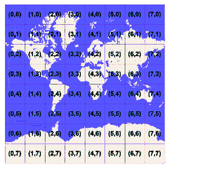
For each zoom level, the whole world surface is divided in tiles. For every zoom level the earth surface is divided in (2 level x 2 level ) tiles, each one of them with 256 x 256 pixels. Each tile is given XY coordinates ranging from (0, 0) in the upper left to (2 level–1, 2 level–1) in the lower right.
EXAMPLE: at level 3 the tile coordinates range from (0, 0) to (7, 7) as shown:
The relationship between World Coordinates (Spherical Mercator coordinates) and XY coordinates (pixel coordinates) is calculated using the formula:
pixelX=floor ( (x+20037508.34) / (156543.0339 * 2 -level ))
pixelY=floor ( (20037508.34 - y) / (156543.0339 * 2 -level ))
Given a pair of pixel XY coordinates, it’s easy to determine the tile XY coordinates of the tile containing that pixel:
tileX = floor(pixelX / 256)
tileY = floor(pixelY / 256)
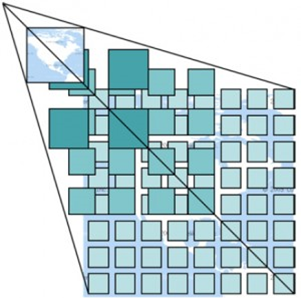
To optimize the indexing and storage of tiles, the two-dimensional tile XY coordinates are combined into one-dimensional strings called quadtree keys. Each quadtree key uniquely identifies a single tile at a particular zoom level.
To convert tile coordinates into a quadtree key, the bits of the Y and X coordinates are interleaved, and the result is interpreted as a base-4 number (with leading zeros maintained) and converted into a string. For instance, given tile XY coordinates of (7, 5) at level 3, the quadtree key is determined as follows:
tileX = 7 = 111 (binary)
tileY = 5 = 101  (binary)
quadtree key = 110111   (binary) = 313  (base-4) = “313”
The length of a quadtree key (the number of digits) equals the level of detail (zoom level) of the corresponding tile.
The quadtree key of any tile starts with the quadtree key of its parent tile (the containing tile at the previous level).
DATile
This service returns the requested tile.
The tile can be from any of the available views: ortho, north, east, west and south. The ortho view is the one generated from vertical images, which are properly rectified according to the underlying DTM; while for the rest of the views the corresponding oblique images were processed and rectified according to the DTM.
Tiles are returned as jpg images.
Besides the aerial images, the system is ready to deliver overlay data. This is rasterized vector data with transparency, which can be displayed on top of the images. This information is delivered as transparent png files and is grouped in layers. The layers can have information for one or all of the supported views, so that the information properly matches the different image views. GetTile service can be configured to server an extra zoom level, resampling last real zoom level tiles. This feature must be enabled in the user profile settings.
DATile Parameters
- id [mandatory]: Tile ID, it will be a sequence of digits, which only will be able to contain 0, 1, 2 and 3. This nomenclature corresponds to the way of codifying the Tiles for quadtrees.
- Layer [mandatory]: Name of the layer (orientation) to which the requested Tile belongs to. Supported values are:
- Ortho: For the ortho images.
- North: For the orthorectified North view images.
- South: For the orthorectified South view images.
- East: For the orthorectified East view images.
- West: For the orthorectified West view images.
- crs [mandatory]: Projection system used. It must follow OGC nomenclature. For example EPSG:32630 for UTM 30 North WGS84 or EPSG:3857 for Spherical Mercator projection.
- overlay [optional]: If this parameter is present, instead of returning tiles from the aerial images, it will return tiles from the specified overlay layer. The system has a “generic” overlay layer available, with the streets, roads and main political divisions.
- userkey [mandatory]: User’s key for authentication purposes. This key is unique for each client and must be requested to Field Group.
- time [optional]: A date following the structure YYYYMMDD or YYYYMM or YYYY. The service will use the most current images available, whose date is previous to the requested date. It is also possible to use a range of dates with the structure YYYYMMDD-YYYYMMDD, in this case the images used will be the most current ones available in the specified date range. If the parameter is omitted the system will submit the most recent version of the tile.
- baselayer [optional]: If this parameter is present, instead of returning tiles from the aerial images, it will return tiles from the specified baselayer.
- ExtraZoom [optional]: This parameter allows disable extra zoom feature for current request. This behavior can be useful to confirm if current is real or resampled tile.
Usage
https://your.mapspace.com/mapSvcs/DATile?userkey=********&id=033111001210321200&crs=epsg:3785&baselayer=ortho
In the example above, tile 033111001210321200 from the ortho image from the images collection with Spherical Mercator coordinate system is requested.
The result of the request will be a JPG image. If the user is not authorized to obtain the requested data or if the requested tile is not available, then a transparent PNG file 256 x 256 pixels will be returned.
WMTS
Mapspace offers a WMTS (Web Map Tile Service) as an ortho and ortho-rectified tiled image provider complying with the directives and OGC's regulation.
The service has been developed to provide 256x256 pixel tile image inside the matrix described in the ‘GetCapabilities’ metadata response. At this moment all ortho and ortho-rectified layers available in Mapspace can be requested using this mechanism.
The service requires an https request with the parameters normalized by OGC.
These parameters are service, version, type of request, layer name, name of the matrix, matrix set referred, the ordinal number (x and y) of the tile inside the layer’s matrix and the expected image format.
WMTS Supported Versions
Current supported WMTS version is 1.0.0. Refer to the OGC WMTS to obtain more information about mandatory and optional parameters for this: http://www.opengeospatial.org/standards/wmts
WMTS Supported Matrix systems
Mapspace WMTS service supports several matrix systems. Default is EPSG:4326, but optimal is EPSG:3785. A complete list is available online in GetCapabilities URL:
https://your.mapspace.com/mapSvcs/DAWMTS?userkey=XXXXX&service=WMTS&request=GetCapabilities
Note: Different coordinate reference systems can be supported. Contact your local Field Group Sales if necessary
WMTS Usage
To connect to the Mapspace WMTS service from a GIS client, it is necessary to setup the following URL:
http://your.mapspace.com/mapSvcs/DAWMTS?userkey=[userkeystring]
In this request, userkeystring must be replaced by the unique platform access key provided by Field Group. Then GetCapabilities will return information about TileMatrix and layers available.
At this moment, we have five different ones. They are the vertical ortho and the four ortho-rectified views (north, south, east and west). Standard Ortho requests are available from zoom level 1 to 20 but on rectified views, zoom level value should be set between 15 and 20.
Example:
https://your.mapspace.com/mapSvcs/DAWMTS?userkey=XXXXXX&SERVICE=WMTS&REQUEST=GetTile&VERSION=1.0.0&LAYER=Mapspace:ORTHO:3067&TILEMATRIXSET=EPSG:3067&TILEMATRIX=EPSG:3067:3&TILECOL=1&TILEROW=3&FORMAT=image/jpeg&STYLE=_null
WMTS Parameters
- Version [mandatory]: This parameter is the WMTS version that is used in the request. Only one value is accepted in the current implementation:
- 1.0.0
- Request [mandatory]: The type of service GetTile. Possible values are:
- GetTile. Used for retrieving a tile.
- GetCapabilities used to obtain the web services descriptor metadata xml file.
- GetFeatureInfo used to retrieving the available information (date & copyright) in pixel location inside the requested image.
- Layers [mandatory]: Identifies which view is being requested. Possible values are:
- Mapspace:ORTHO: For the vertical images.
- Mapspace:NORTH: For the orthorectified North view images.
- Mapspace:SOUTH: For the orthorectified South view images.
- Mapspace:EAST: For the orthorectified East view images.
- Mapspace:WEST: For the orthorectified West view images.
- Style [mandatory]: Parameter mandatory for WMTS Standard. The only supported value is default.
- Tilematrixset [mandatory]: WMTS requires the ability to define Tile Matrix Sets. A tile matrix set controls what tiles are available for a layer.
- Tilematrix [mandatory]: Name of the tile matrix the tile requested is being referred to. Every tile matrix inside Mapspace is referred to a different zoom level, thus divides the world into a different number of tiles, starting on zoom level one (dividing the world into a 2x2 tiles matrix) to zoom level 20 (dividing the world into a 1048576x 1048576 tile matrix). Nomenclature for tile matrices is: NameOfTileMatrix:NumberOfZoom. That is, level 5 in our only tile matrix set would be: EPSG:3857:5
- Tilerow [mandatory]: Number of the row the tile requested belongs to, inside the requested matrix.
- Tilecol [mandatory]: Number of the column the tile belongs to, inside the requested matrix.
- Format [mandatory]: Image format. Supported formats are image/jpeg/mixed. Mixed mode change the service behaviour allowing us to receive a jpeg or png image. We will receive a jpeg image if requested area has full coverage by Mapspace data (allowed layers for user). If not, we will receive a png image with a transparent data for missing coverage area.
- Userkey [mandatory]: User’s key for authentication purposes. This key is unique for each client and must be requested from Field Group.
- Nodata [optional]: This specifies the output format for the non-available data request (no image coverage). Allowed parameters are:
- empty: Response will be empty (not file provided)
- transparent: Response will be a transparent png tile.
- baselayer [optional]: If this parameter is present, instead of returning tiles from the aerial images, it will return tiles from the specified baselayer.
- ExtraZoom [optional]: Allows get one extra zoom level resampling previous zoom level tiles. Possible values are true/false. If required, it is possible to set a default value when parameter is missing.
- Time [optional]: A date following the structure YYYYMMDD or YYYYMM or YYYY. The service will return the most recent image available starting from the year provided. It is also possible to use a range of dates with the structure YYYYMMDD-YYYYMMDD. In this case the returned image will be the most recent one available in the specified range. If the parameter is omitted the system will submit the most recent version of the imagery.
- Service: This parameter is mandatory with a fixed value set to WMTS.
- Query_layers [Mandatory GetFeatureInfo]: The layer name to be used as source.
- Info_format [Optional GetFeatureInfo]: The output format for GetFeatureInfo. Available formats are ‘text/plain’, ‘text/xml’, ‘application/json’ & ‘application/gml+xml; version=3.1’ (last one is default format).
- I (or X) [Mandatory GetFeatureInfo]: X Pixel (Tile) location of GetFeatureInfo request
- J (or Y) [Mandatory GetFeatureInfo]: Y Pixel (Tile) location of GetFeatureInfo request
WMTS GetCapabilities
To obtain the metadata xml file with the description of the WMTS service call, the request parameter must be set to “GetCapabilities”. It must be also necessary to fill out the service and userkey parameters.
Example:
https://your.mapspace.com/mapSvcs/DAWMTS?userkey=XXXXX&service=WMTS&request=GetCapabilities
The result would be an xml file with the capabilities of the WMTS.
WMTS GetFeatureInfo
To obtain the metadata information: Copyright & Date Interval, the request parameter must be set to “GetFeatureInfo”. The request parameter list must be equal to ‘GetTile’ request with the mandatory parameters of GetFeatureInfo service.
Example:
https://your.mapspace.com/mapSvcs/DAWMTS?userkey=XXXXXXX*&SERVICE=WMTS&VERSION=1.0.0&REQUEST=GetFeatureInfo&BASELAYER=&layer=Mapspace%3AORTHO&style=default&tilematrixset=EPSG%3A3857&Format=image%2Fjpeg&TileMatrix=EPSG%3A3857%3A19&TileCol=256776&TileRow=197622&I=128&J=150&QUERY_LAYERS=ortho&INFO_FORMAT=text/xml
The result would be an xml file with the Copyright and Date interval like the one shown below.
<?xml version="1.0" encoding="UTF-8"?>
<result>
	<copyright>Blom</copyright>
	<dateMin>2009-10-15</dateMin>
	<dateMax>2009-10-15</dateMax>
</result>"
WMTS Tile Matrix Set – The geometry of the Tile Space
In a tiled map layer, the representation of the space is constrained in a discrete set of parameters. A tile matrix set defines these parameters. Each tile matrix set contains one or more "tile matrices" defining the tiles that are available for that coordinate reference system. Each tile matrix specifies:
a) The scale of the tiles as a scale denominator: The scale denominator is defined with respect to a "standardized rendering pixel size" of 0.28 mm × 0.28 mm (millimeters). The definition is the same used in WMS 1.3.0 [OGC06-042] and in Symbology Encoding Implementation Specification 1.1.0 [05-077r4].
Frequently, the true pixel size is unknown and 0.28 mm is a common actual size for current displays.
b) The width and height of each tile in pixels.
c) The top left (minimum x, maximum y) corner of the bounding box of the tile matrix (i.e., the CRS coordinates of the top left corner of the top left pixel of the top left tile).
d) The width and height of the tile matrix in tile units (i.e., number of tiles).
The number of tile matrix sets that a WMTS server serves for a particular layer is:
nTileMatrices × nTiledStyles × nTiledFormats
If no dimensions are defined or:
nTileMatrices × nTiledStyles × nTiledFormats × nTiledDimensions
If dimensions are defined, the number of distinct tiles within each tile matrix of a tile matrix set (i.e., for a particular scale within a tile-matrix set) is a product of:
matrixWidth × matrixHeight
Each tile matrix set defines its own set of scale levels corresponding with the contained tile matrices. Each layer references one or more tile matrix sets. Although each layer could reference a different tile matrix set, it is likely that a server will offer many layers with the same tile matrix set reference.
A tile matrix set is composed of a collection of tile matrices, each one with a resolution optimized for a particular scale and identified by a tile matrix identifier
Each tile matrix set has an optional approximated bounding box but each tile matrix has an exact bounding box that is deduced indirectly from other parameters. Tile matrix bounding boxes at each scale will usually vary slightly due to pixel alignment, and it is important for the client and server to take this variation into account. Given the top left point of the tile matrix in CRS coordinates (tileMatrixMinX, tileMatrixMaxY), the width and height of the tile matrix in tile units (matrixWidth, matrixHeight), the width and height of a tile in pixels (tileWidth, tileHeight), the coefficient to convert the coordinate reference system (CRS) units into meters (metersPerUnit) and the scale (1:scaleDenominator), the bottom right corner of the bounding box of a tile matrix (tileMatrixMaxX, tileMatrixMinY) can be calculated as follows:
pixelSpan = scaleDenominator × 0.28 10-3 / metersPerUnit (crs);
tileSpanX = tileWidth × pixelSpan;
tileSpanY = tileHeight × pixelSpan;
tileMatrixMaxX = tileMatrixMinX + tileSpanX × matrixWidth;
tileMatrixMinY = tileMatrixMaxY - tileSpanY × matrixHeight;
The tile space therefore looks like this:
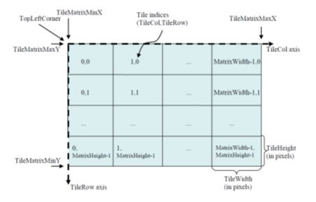
Each tile in a tile matrix is identified by its TileCol and TileRow indices that have their 0,0 origin in the tile next to the top left corner of the tile matrix and that increases towards the right and towards the bottom respectively, as shown in figure 2. Annex H in this document includes pseudo code that illustrates the process for obtaining the tile indices that cover a bounding box rectangle and also the computation to get the CRS coordinates that bound a tile.
NOTE 1 Non-square pixels are not supported. This is different from WMS, which does allow nonsquare pixels (although many implementations fail to support this properly).
A tiled layer links to its tile matrix set through a TileMatrixSet URI that points to a TileMatrixSet section that completely defines it as previously explained. A layer can use a specific TileMatrixSet that describes a region adjusted to the actual content of this layer. In this case, the optional TileMatrixSetLimits section will not be used and changes in spatial extension of the layer can affect the minimum bounding box of the layer forcing to redefine the TopLeftCorner of each TileMatrix and that will end up changing the TileCol, TileRow indexes thereby invalidating any previously cached tile.
WMS
Web Map Service (WMS) is a standard protocol for serving georeferenced map images over the Internet, in our case generated by Mapspace using the data stored in its internal database.
Mapspace offers the WMS service to allow users to access the vertical and rectified oblique imagery following OGC's regulation and directives.
The service uses the https protocol with the parameters normalized by OGC, which define version, type of request, coordinate system, bounding box, etc.
WMS Supported Versions
Current supported WMS versions are 1.1.1 and 1.3.0. You can refer to the OGC WMS to obtain more information about mandatory and optional parameters for WMS requests.
WMS Supported Geo-Referenced systems
Mapspace WMS service supports several geo-referenced systems. Default is EPSG:4326, but optimal is EPSG:3785. A complete list is available online in GetCapabilities URL:
https://your.mapspace.com/mapSvcs/DAWMS?userkey=XXXXX&service=WMS&request=GetCapabilities
Note: Different coordinate reference systems can be supported. Contact your local Field Group Sales if necessary.
WMS Usage
To connect to the Mapspace WMS service from a GIS client, it is necessary to setup the following URL:
http://your.mapspace.com/mapSvcs/DAWMTS?userkey=[userkeystring]
In this request, userkeystring must be replaced by the unique platform access key provided by Field Group. Then GetCapabilities will return information about projection systems and layers available. In the current version, 5 layers are supported, the ortho and the four mosaic rectified views (north, south, east and west) for each supported projection.
WMS Parameters
Parameters defined by OGC standard are:
- Version [mandatory]: This parameter is the WMS version that is used for this request. Only two values are accepted in the current API version:
- 1.1.1
- 1.3.0
- Request [mandatory]: Possible values are:
- GetMap. Used for retrieving an image/map.
- GetCapabilities used to obtain the web services descriptor xml file.
- GetFeatureInfo used to retrieving the available information (date & copyright) in pixel location inside the requested image.
- Layers [mandatory]: Identifies which view the user is requesting. Possible values:
- Ortho: For the ortho images.
- North: For the orthorectified North view images.
- South: For the orthorectified South view images.
- East: For the orthorectified East view images.
- West: For the orthorectified West view images.
- Styles [mandatory]: Parameter mandatory for WMS Standard, it must be present but its value is ignored by Mapspace.
- Crs or srs [mandatory]: Projection system used. It must follow OGC nomenclature. For example EPSG:4326 for WGS84 LATLON or EPSG:3857 for Spherical Mercator projection.
- Bbox [mandatory]: requested extent, following the rules of the WMS Standard: Xmin, Ymin, Xmax, Ymax
- Width [mandatory]: Width of the requested image in pixels.
- Height [mandatory]: Height of the requested image in pixels.
- Format [mandatory]: Image format. Supported formats are image/jpeg/mixed. Mixed mode change the service behaviour allowing us to receive a jpeg or png image. We will receive a jpeg image if requested area has full coverage by Mapspace data (allowed layers for user). If not, we will receive a png image with a transparent data for missing coverage area.
- UserKey [mandatory]: User’s key for authentication purposes. This token is unique for each client and must be requested from Field Group.
- Time [optional]: A date following the structure YYYYMMDD or YYYYMM or YYYY. The service will return the most recent image available starting from the year provided. It is also possible to use a range of dates with the structure YYYYMMDD-YYYYMMDD. In this case the returned image will be the most recent one available in the specified range. If the parameter is omitted the system will submit the most recent version of the imagery.
- Service: This parameter is mandatory with a fixed value set to WMS.
- baselayer [optional]: If this parameter is present, instead of returning tiles from the aerial images, it will return tiles from the specified baselayer.
- Overlay [optional]: The overlay name to be used as data source. Returns PNG format image.
- ExtraZoom [optional]: Allows get one extra zoom level resampling previous zoom level tiles. Possible values are true/false. If required, it is possible to set a default value when parameter is missing.
- Query_layers [Mandatory GetFeatureInfo]: The layer name to be used as source.
- Info_format [Optional GetFeatureInfo]: The output format for GetFeatureInfo. Available formats are ‘text/plain’, ‘text/xml’, ‘application/json’ & ‘application/vnd.ogc.gml’ (last one is default format).
- X (or I) [Mandatory GetFeatureInfo]: X Pixel location of GetFeatureInfo request.
- Y (or J) [Mandatory GetFeatureInfo]: Y Pixel location of GetFeatureInfo request.
WMS GetCapabilities
To obtain the metadata xml file with the description of the WMS service call, the request parameter must be set to “GetCapabilities”. It must be also necessary to fill out the service and userkey parameters.
Example:
https://your.mapspace.com/mapSvcs/DAWMS?userkey=XXXXX&service=WMS&version=1.1.1&request=GetCapabilities
The result would be an xml file with the capabilities of the WMS.
WMS GetFeatureInfo
To obtain the metadata information: Copyright & Date Interval, the request parameter must be set to “GetFeatureInfo”.
Example:
https://your.mapspace.com/mapSvcs/DAWMS?VERSION=1.1.1&SERVICE=WMS&REQUEST=GetFeatureInfo&LAYERS=ortho&QUERY_LAYERS=ortho&FORMAT=image/jpeg&STYLES=&SRS=EPSG:3857&BBOX=1195100.282,8377811.596,1196943.655,8378593.082&X=540&Y=252&INFO_FORMAT=text/plain&WIDTH=1420&HEIGHT=602&userkey=xxxxxx
The result would be an txt file with the Copyright and Date interval like the one shown below.
Blom,2014-07-04,2014-07-04
WMS GetMap
The result of the GetMap request will be a JPG image with the requested AOI. If the user is not authorized to access this AOI or layer, a black JPG file with the text ‘unauthorized’ will be returned.
If the requested data is not available in the expected resolution level, the service checks in the next two upper zoom levels. In case of matching, the service will take this imagery, applying a digital zoom effect to adapt it to the bounding box and resolution requested by the user.
If no imagery is available a black JPG is returned.
https://your.mapspace.com/mapSvcs/DAWMS?userkey=XXXXXX&service=WMS&version=1.1.1&request=GetMap&srs=EPSG:3857&bbox=-523000,4960000,-521500,4961500&width=550&height=550&layers=ortho&format=image/jpeg&styles=
WMS/WMTS Basic Authentication
These WMS/WMTS services version has been implemented to support standard basic authentication and the access to ortho baselayers (no transparency) and ortho overlays (transparency).
Baselayer and Overlay layers availability can be obtained through 'GetCapabilities' request or through the INUserOrthoLayers & INUserOverlayLayers services, section 'User Information Services'.
GetCapabilities connection to Mapspace WMS/WMTS services must be done through the next URLs:
- Baselayers
WMS -> https://your.mapspace.com/mapSvcs/WMS?request=GetCapabilities&version=1.3.0&service=WMS
WMTS -> https://your.mapspace.com/mapSvcs/WMTS?&SERVICE=WMTS&VERSION=1.0.0&REQUEST=GetCapabilities
- overlays
WMS -> https://your.mapspace.com/mapSvcs/OVWMS?request=GetCapabilities&version=1.3.0&service=WMS
WMTS -> https://your.mapspace.com/mapSvcs/OVWMTS?&SERVICE=WMTS&VERSION=1.0.0&REQUEST=GetCapabilities
These new services will work without Userkey validation, so Mapspace web credentials will be requried for the authentication.
Note: Oblique mosaics will not available on these services.
INMap
Additionaly to the GetFeatureInfo request on WMS/WMTS services, this service is intended to provide copyright and date information about ortho images and overlays.
The service can be asked to share the information of the ortho images or overlays covering a certain ground extent or a single point. When requested, the service will publish the copyright, minimum date and maximum date when the images were taken for the ortho images covering that area/point meeting the criteria specified with the parameters of the request.
Finally, results will be filtered by user date restrictions.
If no information is available, this service will deliver an error notice saying that no data is available for the request.
INMap Parameters
- layers [mandatory]: Identifies which view the user is requesting. Possible values:
- Ortho: For the ortho images.
- North: For the orthorectified North view images.
- South: For the orthorectified South view images.
- East: For the orthorectified East view images.
- West: For the orthorectified West view images.
- crs [mandatory]: Projection system used, It must follow OGC nomenclature. For example EPSG:4326 for WGS84 LATLON or EPSG:3857 for Spherical Mercator projection.
- x [mandatory if requesting information in a point]: X coordinate of the point of which the information is being requested, on the projection system indicated by crs.
- y[mandatory if requesting information in a point]: Y coordinate of the point of which the information is being requested, on the projection system indicated by crs.
- zoom [mandatory if requesting information in a point]: Zoom level of the ortho images of which the information is being requested.
- maxx [mandatory if requesting information in a extent]: X coordinate of the highest point that defines the extent of which the information is being requested.
- maxy [mandatory if requesting information in a extent]: Y coordinate of the highest point that defines the extent of which the information is being requested.
- minx [mandatory if requesting information in a extent]: X coordinate of the lowest point that defines the extent of which the information is being requested.
- miny [mandatory if requesting information in a extent]: Y coordinate of the lowest point that defines the extent of which the information is being requested.
- width [mandatory if requesting information in a extent]: Width of the requested image in pixels. It will be used to calculate the best suited zoom for the image on that extent.
- height [mandatory if requesting information in a extent]: Height of the requested image in pixels. It will be used to calculate the best suited zoom for the image on that extent.
- userkey [mandatory]: User’s Token for authentication purposes. This token is unique for each client and must be requested to Field Group.
- date [mandatory] : A date following the structure YYYY to specify one year or YYYY-YYYY to specify a range of years. If a range is specified, the service will look for information of the ortho images taken in that range of years. If only a year is specified, the service will look for information of ortho images taken before that year.
- bLayer [optional]: String indicating the base layer preference for the request, formatted as baselayer1,baselayer2,baselayer3. If not set, default baselayer preference shall be ortho,countryortho,satellite.
- olay [optional]: If requesting information about an overlay layer image, this parameter would indicate the name of the overlay of which the information is being requested.
- output [optional]: Format in which the service will send the response. Allowed formats are: txt (Text), xml and js (Javascript). If no format is set, xml format will be default format.
Usage
https://your.mapspace.com/mapSvcs/INMap?userkey=XXXXXX&crs=EPSG:3857&xmin=1389525.984992505&ymin=5145333.536935514&xmax=1389530&ymax=5145340&height=400&width=500&layer=NORTH&zoom=17&date=2009-2006&output=xml
The result of the request will be 3 Strings indicating the images copyright, the minimum date when the images were taken and the maximum date when the images were taken. Depending on the format chosen in the parameters of the request, the result will be presented on 3 different ways:
-
output=xml: The result will be the following xml:
<?xml version="1.0" encoding="UTF-8"?> <result> <copyright>copyright</copyright> <dateMin>date</dateMin> <dateMax>date</dateMax> </result> -
output=txt: The result would be a string made by concatenating the copyright, dateMin and dateMax strings separated by “,”.